NOTICE OF PUBLIC HEARING
CITY OF HOUGHTON PLANNING COMMISSION
PROPOSED ORDINANCE AMENDMENT
THE CITY OF HOUGHTON PLANNING COMMISSION WILL HOLD A PUBLIC HEARING AT 5:30 p.m. TUESDAY, DECEMBER 2, 2025, IN THE HOUGHTON CITY CENTER COUNCIL CHAMBERS, 616 SHELDEN AVENUE, ON THE FOLLOWING PROPOSED ORDINANCE:
CITY OF HOUGHTON
PROPOSED
ORDINANCE 2025-342
AN ORDINANCE, PURSUANT TO CHAPTER 98, SECTION 4, (98-4),
OF THE CODE OF ORDINANCES, CITY OF HOUGHTON
TO RE-ZONE PROPERTY
THE CITY OF HOUGHTON ORDAINS:
Pursuant to Chapter 98, Section 4, (98-4), the Code of Ordinances, City of Houghton, Michigan and Public Act 110 of 2006, as amended, the following-described property is re-zoned from RSV (reserve) to R-3 (multiple-family residential district):
A parcel of land situated in part of Block 3 of the Supervisor’s Plat of East Houghton, according to the plat recorded in Liber 2 of Plats, Page 32 of Houghton County Records, City of Houghton, Houghton County, Michigan, described as follows:
Commencing at the East Quarter corner of Section 36, Township 55 North, Range 34 West; then along the East line of Section 36, N01°01’34″E 526.92 feet (previously recorded as North 518.6’) to the Southeast corner of said Block 3; then along the South line of said Block 3, N81°20’31″W (previously recorded a N82°23’W and N78°15’W) 523.25 feet to the POINT OF BEGINNING;
then continuing along said South line of said Block 3, N81°20’31″W (previously recorded a N82°23’W and N78°15’W) 744.75 feet to the Southwest corner of said Block 3; then along the West line of said Block 3, N08°18’14″E (previously recorded as N07°37’E and N11°45’E) 136.32 feet; then S88°26’05″E 8.82 feet; then 75.05 feet along a 300.00 foot radius curve to the right with a delta angle of 14°20’03” and a chord bearing S81°16’03″E 74.86 feet; then S74°06’01″E 74.89 feet; then 267.26 feet along a 2130.00 foot radius curve to the left with a delta angle of 07°11’21” and a chord bearing S77°41’41″E 267.08 feet; then S81°17’22″E 222.40 feet; then 84.04 feet along a 4870.00 foot radius curve to the right with a delta angle of 00°59’20” and a chord bearing S80°47’42”E 84.04 feet; then S01°01’34”W 110.86 feet to the POINT OF BEGINNING, containing 2.00 acres, more or less.
SUBJECT TO
A variable width trail easement situated in part of Block 3 of the Supervisor’s Plat of East Houghton, according to the plat recorded in Liber 2 of Plats, Page 32 of Houghton County Records, City of Houghton, Houghton County, Michigan, described as follows:
Commencing at the East Quarter corner of Section 36, Township 55 North, Range 34 West; then along the East line of Section 36, N01°01’34″E 526.92 feet (previously recorded as North 518.6’) to the Southeast corner of said Block 3; then along the South line of said Block 3, N81°20’31″W (previously recorded a N82°23’W and N78°15’W) 523.25 feet; then N01°01’34” 107.00 feet to the POINT OF BEGINNING; then N79°16’56″W 55.44 feet; then N86°27’16″W 107.42 feet; then N69°03’25″W 57.94 feet; then S81°17’22″E 134.46 feet;
then 84.04 feet along a 4870.00 foot radius curve to the right with a delta angle of 00°59’20” and a chord bearing S80°47’42”E 84.04 feet; then S01°01’34”W 3.86 feet to the POINT OF BEGINNING, containing 0.03 acres, more or less.
ALSO SUBJECT TO
A variable width sanitary sewer easement situated in part of Block 3 of the Supervisor’s Plat of East Houghton, according to the plat recorded in Liber 2 of Plats, Page 32 of Houghton County Records, City of Houghton, Houghton County, Michigan, described as follows:
Commencing at the East Quarter corner of Section 36, Township 55 North, Range 34 West,
then along the East line of Section 36, N01°01’34″E 718.74 feet; then due West 531.64 feet
to the POINT OF BEGINNING; then N84°23’45″W 419.50 feet; then N72°27’53″W 302.49 feet;
then N08°18’14″E 1.89 feet; then S88°26’05″E 8.82 feet; then 75.05 feet along a 300.00 foot radius curve to the right with a delta angle of 14°20’03” and a chord bearing S81°16’03″E 74.86 feet; then S74°06’01″E 74.89 feet; then 267.26 feet along a 2130.00 foot radius curve to the left with a delta angle of 07°11’21” and a chord bearing S77°41’41″E 267.08 feet; then S81°17’22″E 222.40 feet; then 70.96 feet along a 4870.00 foot radius curve to the right with a
delta angle of 00°50’05” and a chord bearing S80°52’19″E 70.96 feet to the POINT OF BEGINNING, containing 0.24 acres, more or less.
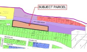
A portion of the Houghton City Zoning Map, as amended to reflect such re-zoning, is shown below as Exhibit A.
The public hearing is a chance for the planning commission to receive public comments on this proposed ordinance. Copies of the proposed ordinance are available at the Houghton City Clerk’s Office, 616 Shelden Avenue, Houghton between the hours of 8-4:30 on weekdays and on our website cityofhoughton.com. The office number is 906-482-1700.
Amy Zawada, Clerk
